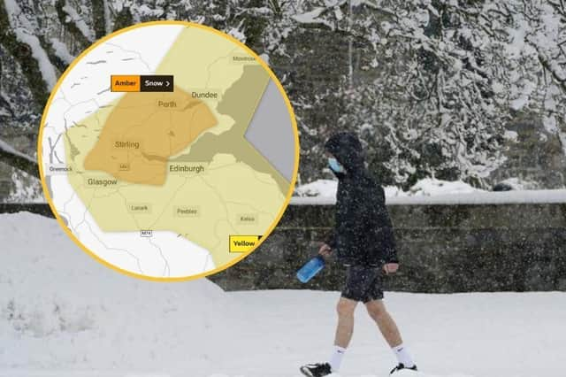
Falkirk weather: Met Office issue amber warning for snow in Falkirk and the central belt


The Amber warning is in place across the central belt, including Stirling, Falkirk, Perth and parts of Fife.
Before this warning was announced, the Met Office has previously issued a yellow warning for snow across the central belt and the north east of Scotland that will remain in place
until 11.59pm on Wednesday.
Advertisement
Hide AdAdvertisement
Hide AdThe initial warning covers south west Scotland, the Lothians, Grampian, Highland, Strathclyde, Central, Tayside and Fife.
A statement on the Met Office website about amber warning says: “Snow showers are expected to continue during Monday night and Tuesday with some large accumulations building up in parts of central Scotland.
"Across the area 5-10 cm of snow is expected to lie fairly widely with areas of 10-20 cm, perhaps particularly over higher parts of the Central Belt and the chance of 25 cm of snow in one or two spots.”
Ice was initially predicted across the country but experts dropped that prediction in favour of snow being the primary risk.
Advertisement
Hide AdAdvertisement
Hide AdHeavy snow will "at times bring some travel disruption", the Met Office said, leading to travel delays, possible cancellations to rail and air services, power and phone interruptions and the possibility that some rural communities may become cut off.
Temperatures across the central belt are forecast to remain low today, rising from freezing to 1°C, but experts have forecast that it is expected to feel more like -5°C or -6°C.
Similarly, the north east of Scotland is expected to see temperatures close to freezing today but the Met Office has said that it will feel like -4°C or -5°C.
Forecasters are warning of a strong chance of roads becoming blocked by deep snow, "with many stranded vehicles and passengers likely". Snow accumulations of 5-10 centimetres will be widespread in the affected area, and reaching up to 30cm in "a few sites".
Advertisement
Hide AdAdvertisement
Hide AdA statement on the Met Office website said: “Snow showers will feed off the North Sea into many northern and eastern areas of the UK.
“Some icy stretches are possible overnight, mainly where melting snow during the afternoon has not a chance to dry out before freezing overnight, although snow is likely to be more prevalent.”