Union Canal: Aerial images show extent of breach near Whitecross and Muiravonside
and live on Freeview channel 276
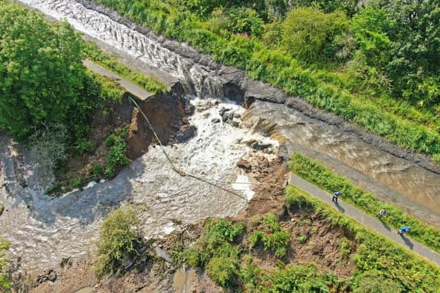
These aerial images taken by Scottish Canals show the extent of the Union Canal breach near Whitecross.
The canal burst its banks in the early hours of Wednesday morning as torrential rain and thunderstorms battered the country.
Advertisement
Hide AdAdvertisement
Hide AdA 30 metre wide breach was reported near Whitecross and Muiravonside where part of the towpath was washed away.
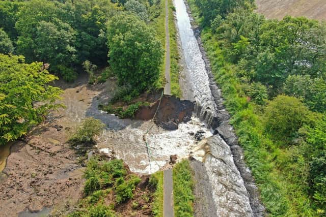

Water flowing through the breach has had a huge impact on the Edinburgh to Glasgow railway line with all trains suspended and an expectation that it could be a number of weeks before the line re-opens.
Work is ongoing to reduce the flow of water passing through the breach.
In its latest update on the situation, Scottish Canals said: “Last night we continued to install emergency dams (sandbags etc) at the site and this significantly reduced the flow and volume of water passing through the breach.
Advertisement
Hide AdAdvertisement
Hide Ad"Contractors have been on site since 7.30am installing clay dams 100m to the west of the breach and 150m to the east in order to reduce the flow of water further.
"This will mitigate the impact to the Edinburgh to Glasgow railway line where services continue to be disrupted.
"These dams are due to be in place within the next 48-72 hours and we are liaising with Network Rail regarding progress and timescales.
“This will also enable us to return water levels to normal in the unaffected section of the canal in order to protect the structure of this scheduled monument.”
Advertisement
Hide AdAdvertisement
Hide AdOn Wednesday staff from Scottish Canals began taking the necessary measures to reduce the flow of water, with stop planks installed at Manse Road Basin in Linlithgow to the east of the site and sandbags at both the A801 canal bridge and at Vellore Road bridge to the west.
The towpath has been closed between the A801 and Vellore Road.
Scottish Canals have been working with Transport Scotland, Network Rail, SEPA, Historic Environment Scotland and Falkirk Council.
The organisation said this stretch of the canal was not identified as a high-risk asset.
Advertisement
Hide AdAdvertisement
Hide AdThey added that as 200-year-old working heritage structures, Scotland’s canals face increasing pressure from climate change.
Freak weather like that experienced overnight on Tuesday brings much higher volumes of water than the scheduled monuments were initially designed to accommodate.
Message from the editor
Thank you for reading this story on our website. While I have your attention, I also have an important request to make of you.
In order for us to continue to provide high quality and trusted local news on this free-to-read site, I am asking you to also please purchase a copy of our newspaper.
Advertisement
Hide AdAdvertisement
Hide AdOur journalists are highly trained and our content is independently regulated by IPSO to some of the highest standards in the world. The dramatic events of 2020 are having a major impact on many of our local valued advertisers and consequently the advertising that we receive. We are now more reliant than ever on you helping us to provide you with news by buying a copy of our newspaper.
Thank you