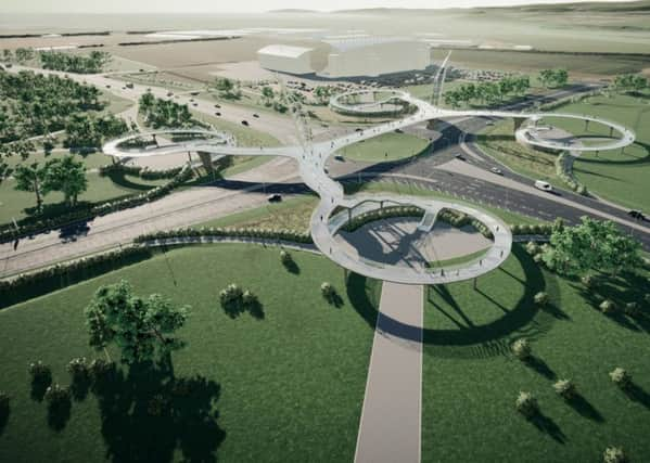
Falkirk Council plans aerial Westfield Crossing to cope with increased traffic


It’s part of a plan that will see the already busy roads that lead to Westfield widened to cope with an increase in traffic when new developments open in the area.
And faced with the challenge of getting people safely across them, the team behind the project came to the conclusion that the only way way was up.
Advertisement
Hide AdAdvertisement
Hide AdColin Frame, principal surveyor with Falkirk Council, explained: “We’ve modelled it to death to try and establish the best way of getting people walking and cycling safely across these roads and it seems an elevated bridge structure is the best solution.”
The bridge will have four ramps swirling up so people with bikes, prams and wheelchairs can reach it from every direction, with stairs for pedestrians.
“Because it’s elevated and the ground around it is relatively flat, it will be a natural viewing platform as well,” said Mr Frame.
“It will add to the Kelpies and be another iconic visitor attraction in its own right – but it will also get people from A to B safely.”
Advertisement
Hide AdAdvertisement
Hide AdThe aim of changing the roads to dual carriageways is to help the flow of traffic to and from the roundabout – particularly at peak times – so simply adding pedestrian crossings would slow things down dramatically.
At the moment, for example, the crossings taking people from Falkirk Stadium to Helix Park have to cope with more than 36,000 movements every month.
But that will only increase as more businesses – including hotels – are built on the sites beside Falkirk fire station and the new Forth Valley College which are earmarked for development as part of the Gateway project.
The aim is also to link up with the town centre, the motorway and Grangemouth, whether driving, walking or cycling.
Advertisement
Hide AdAdvertisement
Hide AdThe bridge, in various guises, has been mooted before but stalled due to funding problems.
This time the funding has been promised from the TIF (Tax Incremental Finance) scheme, which allows local authorities to borrow money against future business rates to improve infrastructure.
This funding was used to put signals on Earls Gate roundabout at junction 6 of the M9 – and junction 5 Cadgers Brae is next on the list.
Comments are welcome on the plans for the new crossing. Visit www.falkirk.gov.uk
Advertisement
Hide AdAdvertisement
Hide AdHowever, there is a long way to go before the project becomes a reality.
People can now see the plans online and make comments which will be taken into account before formal planning permission is submitted, probably in January 2020.
The planning process will mean more consultation, then designs will be finalised by November 2020.
If all goes to plan, what is currently known as the Westfield Crossing would be finished by 2024.